


Verbena Fire Station, Chilton County, Alabama
About
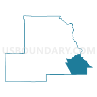
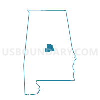
Outline

Summary
| Unique Area Identifier | 521352 |
| Name | Verbena Fire Station |
| County | Chilton County |
| State | Alabama |
| Area (square miles) | 59.41 |
| Land Area (square miles) | 57.82 |
| Water Area (square miles) | 1.58 |
| % of Land Area | 97.34 |
| % of Water Area | 2.66 |
| Latitude of the Internal Point | 32.76739790 |
| Longtitude of the Internal Point | -86.46199290 |
Maps

Graphs
Select a template below for downloading or customizing gragh for Verbena Fire Station, Chilton County, Alabama


Neighbors
Neighoring Voting District (by Name) Neighboring Voting District on the Map
- Clanton Library, Chilton County, AL
- Enterprise Fire Station, Chilton County, AL
- Marbury Community Center, Autauga County, AL
- New Hope Baptist Church, Elmore County, AL
- Pct. 1522 Richville Fire Dept., Coosa County, AL
- Providence , East Chilton Fire Station, Chilton County, AL
- Titus Community Center, Elmore County, AL
Top 10 Neighboring County Subdivision (by Population) Neighboring County Subdivision on the Map
- Clanton CCD, Chilton County, AL (14,329)
- Deatsville CCD, Elmore County, AL (10,104)
- Marbury CCD, Autauga County, AL (5,675)
- Verbena CCD, Chilton County, AL (5,101)
- Titus CCD, Elmore County, AL (4,757)
- Rockford CCD, Coosa County, AL (3,656)
Top 10 Neighboring Place (by Population) Neighboring Place on the Map
Top 10 Neighboring Unified School District (by Population) Neighboring Unified School District on the Map
- Elmore County School District, AL (72,158)
- Autauga County School District, AL (54,571)
- Chilton County School District, AL (43,643)
- Coosa County School District, AL (11,539)
Top 10 Neighboring State Legislative District Lower Chamber (by Population) Neighboring State Legislative District Lower Chamber on the Map
- State House District 88, AL (56,499)
- State House District 42, AL (48,338)
- State House District 31, AL (46,434)
Top 10 Neighboring State Legislative District Upper Chamber (by Population) Neighboring State Legislative District Upper Chamber on the Map
- State Senate District 14, AL (168,669)
- State Senate District 25, AL (157,932)
- State Senate District 30, AL (139,399)
- State Senate District 11, AL (125,111)
Top 10 Neighboring 111th Congressional District (by Population) Neighboring 111th Congressional District on the Map
Top 10 Neighboring Census Tract (by Population) Neighboring Census Tract on the Map
- Census Tract 301, Elmore County, AL (10,104)
- Census Tract 209, Autauga County, AL (5,675)
- Census Tract 607, Chilton County, AL (5,101)
- Census Tract 302, Elmore County, AL (4,757)
- Census Tract 9612, Coosa County, AL (3,656)
- Census Tract 602, Chilton County, AL (2,807)
Top 10 Neighboring 5-Digit ZIP Code Tabulation Area (by Population) Neighboring 5-Digit ZIP Code Tabulation Area on the Map
- 35045, AL (14,870)
- 35046, AL (5,108)
- 36091, AL (3,648)
- 36051, AL (2,304)
- 36080, AL (2,271)
- 35136, AL (1,796)